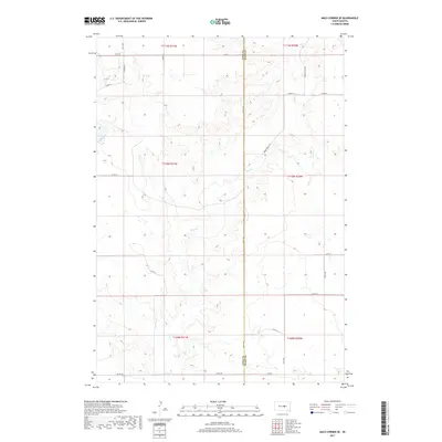
2017 Map of Macs Corner SE
USGS Topo · Published 2017About this map
Elm Cr provides the primary drainage across this rural landscape, carving a winding path through the prairie sections of Hyde and Hand counties. The terrain is defined by the high plains transition, where the township boundaries of T111N, T110N, and T109N meet. This 2017 survey shows a region deeply tied to its sectional grid, where long-established section lines serve as the foundation for the local transportation network. Unlike more densely populated regions, the infrastructure here is almost entirely composed of county roads and avenues like 344th Ave and 208th St, which trace the property boundaries of large agricultural holdings. The sparse settlement pattern is punctuated only by these essential transit corridors, such as Green Valley Rd, illustrating the persistence of the traditional land survey system in modern South Dakota land management.
Find a feature on this map
24 named features on this map. Tap any name to fly to it.
Don’t see what you’re looking for? This feature index may not catch every label — zoom into the map to look around manually.
Map Details
Editions of this 2017 Macs Corner SE Map
This is the sole edition of this map. No revisions or reprints were ever made.
Other maps of this area

1953 · Huron
USGS Topo · 1:250,000

1954 · Huron
USGS Topo · 1:250,000

1966 · Big Bend Dam NE
USGS Topo · 1:24,000

1966 · Stephan
USGS Topo · 1:24,000

1973 · Macs Corner NE
USGS Topo · 1:24,000

1973 · Miller Dale Colony SW
USGS Topo · 1:24,000

1973 · Big Bend Dam 4 NW
USGS Topo · 1:24,000

1973 · Macs Corner SE
USGS Topo · 1:24,000
1973 · Miller Dale Colony NW
USGS Topo · 1:24,000

1973 · Macs Corner
USGS Topo · 1:24,000