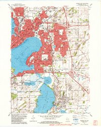
1983 Map of Madison East
USGS Topo · Published 1984About this map
The glacial lakes of Lake Mendota, Lake Monona, and Lake Waubesa define the eastern expansion of Madison during the early 1980s. This survey illustrates the intricate balance between urban density and the surrounding wetlands, where the Yahara River connects the major basins through Upper Mud Lake. Industrial and municipal infrastructure is prominent, including the Blooming Grove TWP Sewage Disposal Pond and the extensive Tank Farm south of the city core. Aviation and education are represented by the sprawling Truax Field and the Madison Area Technical College. To the southeast, the village of McFarland sits at the edge of the marshes, while numerous local landmarks like the Blooming Grove Cem and Roselawn Memorial Park Cemetery provide essential reference points for genealogists tracking the history of Blooming Grove Township and Dunn Township.
Find a feature on this map
71 named features on this map. Tap any name to fly to it.
Don’t see what you’re looking for? This feature index may not catch every label — zoom into the map to look around manually.
Map Details
Editions of this 1983 Madison East Map
This is the sole edition of this map. No revisions or reprints were ever made.
Other maps of this area

1889 · Evansville
USGS Topo · 1:62,500

1890 · Madison
USGS Topo · 1:62,500

1890 · Sun Prairie
USGS Topo · 1:62,500

1890 · Stoughton
USGS Topo · 1:62,500

1892 · Madison
USGS Topo · 1:62,500

1894 · Evansville
USGS Topo · 1:62,500

1896 · Sun Prairie
USGS Topo · 1:62,500

1904 · Madison
USGS Topo · 1:62,500

1905 · Sun Prairie
USGS Topo · 1:62,500

1906 · Evansville
USGS Topo · 1:62,500