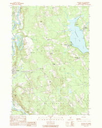
1989 Map of Madison East
USGS Topo · Published 1989About this map
The Kennebec River carves through the western landscape of this Somerset County region, framing the settlements of Anson and Madison. This late-twentieth-century survey reveals a rural network defined by its "Corners"—distinct intersections like Barron Corner, Ellis Corner, and Blackwell Corner—which likely served as historical focal points for local commerce and community life. To the east, the shoreline of Wesserunset Lake is a primary feature, hosting the community of Lakewood and its Golf Course, alongside East Madison at the northern spillway. The topography is marked by several named elevations such as Blackwell Hill and Ward Hill, while the river contains prominent landforms including Weston Island and Savage Island. This map illustrates the transition from riverfront industry and town centers to the lakeside recreation and upland farming common to central Maine.
Find a feature on this map
41 named features on this map. Tap any name to fly to it.
Don’t see what you’re looking for? This feature index may not catch every label — zoom into the map to look around manually.
Map Details
Editions of this 1989 Madison East Map
This is the sole edition of this map. No revisions or reprints were ever made.
Other maps of this area

1892 · Waterville
USGS Topo · 1:62,500

1894 · Norridgewock
USGS Topo · 1:62,500

1898 · Norridgewock
USGS Topo · 1:62,500

1904 · Anson
USGS Topo · 1:62,500

1913 · Skowhegan
USGS Topo · 1:62,500

1943 · Norridgewock
USGS Topo · 1:62,500

1943 · Waterville
USGS Topo · 1:62,500

1948 · Bangor
USGS Topo · 1:250,000

1955 · Anson
USGS Topo · 1:62,500

1955 · Skowhegan
USGS Topo · 1:62,500