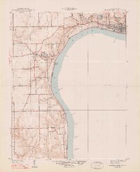
1948 Map of Madison West
USGS Topo · Published 1948About this map
Hanover College overlooks the Ohio River in this detailed study of the riverbank and surrounding uplands surveyed shortly before the 1940s. The landscape is defined by the steep bluffs and dramatic waterfalls of Clifty Falls State Park, where Clifty Creek and its tributaries carve deep into the terrain. Just north of Madison, the State Hospital and County Infirmary mark the social infrastructure of the era, while the Pennsylvania Railroad corridor traces the eastern edge of the sheet. Rural life is anchored by smaller settlements like Hanover and Saluda, connected by State Road No 62. The map provides significant genealogical value, documenting numerous burial grounds including Springdale Cem and Old Bethel Cem, alongside local landmarks like the Antioch Grange and New Prospect Ch.
Find a feature on this map
47 named features on this map. Tap any name to fly to it.
Don’t see what you’re looking for? This feature index may not catch every label — zoom into the map to look around manually.
Map Details
Editions of this 1948 Madison West Map
2 editions found
Other maps of this area

1939 · Bethlehem
USGS Topo · 1:24,000

1939 · Madison West
USGS Topo · 1:24,000

1948 · Bethlehem
USGS Topo · 1:24,000

1948 · Madison West
USGS Topo · 1:24,000

1953 · Madison West
USGS Topo · 1:24,000

1953 · Bedford
USGS Topo · 1:24,000

1953 · Madison East
USGS Topo · 1:24,000

1953 · Bethlehem
USGS Topo · 1:24,000

1956 · Volga
USGS Topo · 1:24,000

1956 · Kent
USGS Topo · 1:24,000