
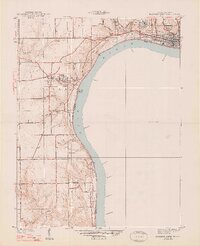
1948 Map of Madison West
USGS Topo · Published 1948About this map
The Ohio River dominates this 1938 topography, winding past the collegiate grounds of Hanover College and the industrial edges of Madison. The landscape is defined by the dramatic drop-offs of the river bluffs, where numerous waterfalls such as Deadman Falls, Butler Falls, and Chain Mill Falls mark the rugged descent to the water. The Pennsylvania railroad line skirts the northern bank, serving the valley's transit needs before the modern era of highway expansion.
Find a feature on this map
49 named features on this map. Tap any name to fly to it.
Don’t see what you’re looking for? This feature index may not catch every label — zoom into the map to look around manually.
Map Details
Editions of this 1948 Madison West Map
2 editions found
Other maps of this area

1939 · Bethlehem
USGS Topo · 1:24,000

1939 · Madison West
USGS Topo · 1:24,000

1948 · Bethlehem
USGS Topo · 1:24,000

1953 · Madison West
USGS Topo · 1:24,000

1953 · Bedford
USGS Topo · 1:24,000

1953 · Madison East
USGS Topo · 1:24,000

1953 · Bethlehem
USGS Topo · 1:24,000

1956 · Volga
USGS Topo · 1:24,000

1956 · Kent
USGS Topo · 1:24,000

1956 · Clifty Falls
USGS Topo · 1:24,000