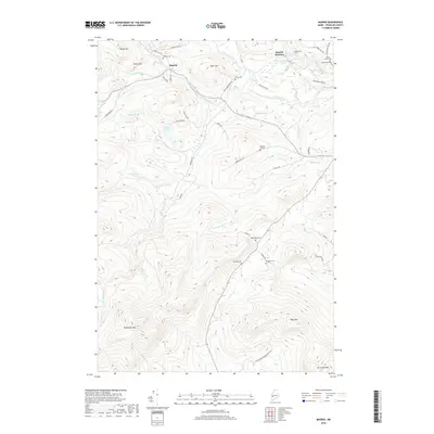
2018 Map of Madrid
USGS Topo · Published 2018About this map
Madrid and Madrid Junction anchor this mountainous section of Franklin County, where the Sandy River and Saddleback Stream carve deep valleys through the high terrain. The geography is defined by prominent peaks including Blueberry Mtn, Pope Mtn, and Hurricane Mtn, with a network of rural roads tracing the lower elevations. Genealogists will find a high concentration of small burial grounds scattered across the hillsides, including the Madrid Cem, Field Cem, and Weld Road Cem. Remote water bodies like Lufkin Pond, Pearl Pond, and Toothaker Pond are tucked between ridges such as Bear Hill and Rowe Hill. The landscape reflects a legacy of high-elevation settlement and forestry, connected by historic routes like Beech Hill Rd and Lufkin Pond Rd that follow the natural contours of the river valleys and stream beds.
Find a feature on this map
55 named features on this map. Tap any name to fly to it.
Don’t see what you’re looking for? This feature index may not catch every label — zoom into the map to look around manually.
Map Details
Editions of this 2018 Madrid Map
This is the sole edition of this map. No revisions or reprints were ever made.
Other maps of this area

1926 · Dixfield
USGS Topo · 1:62,500

1927 · Rumford
USGS Topo · 1:48,000

1929 · Phillips
USGS Topo · 1:48,000

1929 · Dixfield
USGS Topo · 1:62,500

1930 · Rumford
USGS Topo · 1:62,500

1932 · Phillips
USGS Topo · 1:62,500

1933 · Rangeley
USGS Topo · 1:48,000

1939 · Rangeley
USGS Topo · 1:62,500

1949 · Rangeley
USGS Topo · 1:62,500

1950 · Lewiston
USGS Topo · 1:250,000