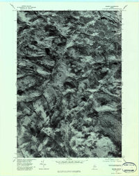
1977 Map of Madrid
USGS Topo · Published 1983About this map
Madrid and Madrid Junction sit at the confluence of several significant waterways in this interior Franklin County landscape. The Sandy River serves as the primary drainage, receiving waters from Saddleback Stream and Orbeton Stream. This 1977 orthophoto quadrangle provides a direct photographic record of the heavy forest cover and mountainous terrain, including the heights of Blueberry Mountain and Pope Mountain. The visible texture of the land reveals the extent of logging roads and natural clearings that defined the region's mid-century economy. Smaller watercourses like Cottle Brook and the South Branch weave through the elevation, showing how the topography dictated the placement of original homesteads and transit routes along the narrow river valleys.
Find a feature on this map
9 named features on this map. Tap any name to fly to it.
Don’t see what you’re looking for? This feature index may not catch every label — zoom into the map to look around manually.
Map Details
Editions of this 1977 Madrid Map
This is the sole edition of this map. No revisions or reprints were ever made.
Other maps of this area

1926 · Dixfield
USGS Topo · 1:62,500

1927 · Rumford
USGS Topo · 1:48,000

1929 · Phillips
USGS Topo · 1:48,000

1929 · Dixfield
USGS Topo · 1:62,500

1930 · Rumford
USGS Topo · 1:62,500

1932 · Phillips
USGS Topo · 1:62,500

1933 · Rangeley
USGS Topo · 1:48,000

1939 · Rangeley
USGS Topo · 1:62,500

1949 · Rangeley
USGS Topo · 1:62,500

1950 · Lewiston
USGS Topo · 1:250,000