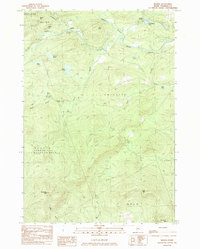
1984 Map of Madrid
USGS Topo · Published 1985About this map
The Sandy River winds through this mountain terrain, defining a landscape shaped by narrow valleys and significant elevation changes near the township of Madrid. In the early 1980s, the area's settlement pattern remained concentrated along the river corridor, with Madrid Junction serving as a notable point of interest where Orbeton Stream meets the main waterway. This survey captures a moment when the regional economy relied on the natural resources of the surrounding hills, evidenced by several Gravel Pits and a network of 4wd tracks penetrating the high ground.
Find a feature on this map
32 named features on this map. Tap any name to fly to it.
Don’t see what you’re looking for? This feature index may not catch every label — zoom into the map to look around manually.
Map Details
Editions of this 1984 Madrid Map
This is the sole edition of this map. No revisions or reprints were ever made.
Other maps of this area

1926 · Dixfield
USGS Topo · 1:62,500

1927 · Rumford
USGS Topo · 1:48,000

1929 · Phillips
USGS Topo · 1:48,000

1929 · Dixfield
USGS Topo · 1:62,500

1930 · Rumford
USGS Topo · 1:62,500

1932 · Phillips
USGS Topo · 1:62,500

1933 · Rangeley
USGS Topo · 1:48,000

1939 · Rangeley
USGS Topo · 1:62,500

1949 · Rangeley
USGS Topo · 1:62,500

1950 · Lewiston
USGS Topo · 1:250,000