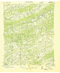
1935 Map of Mages
USGS Topo · Published 1935About this map
Blountville and the surrounding borderlands of Tennessee and Virginia are captured here in detail during a 1935 field examination. The landscape is defined by the tight parallel ridges of Clinch Mountain, Moccasin Ridge, and Walker Mountain, which channel the North Fork Holston River and Moccasin Creek through narrow valleys. This survey documents a rural society organized around crossroads institutions, featuring numerous community nodes such as Arcadia, Mendota, and Hilton. The presence of the Southern Railway through Poor Valley highlights the era's reliance on rail transport for moving goods and people through the Appalachian foothills. Genealogists will find significant value in the documentation of family-named landmarks and local burial grounds like Pyles Cem and South Fork Cem, alongside a dense network of small schools such as Gold Springs Sch and Indian Springs Sch.
Find a feature on this map
70 named features on this map. Tap any name to fly to it.
Don’t see what you’re looking for? This feature index may not catch every label — zoom into the map to look around manually.
Map Details
Editions of this 1935 Mages Map
This is the sole edition of this map. No revisions or reprints were ever made.
Other maps of this area

1891 · Roan Mountain
USGS Topo · 1:125,000

1892 · Greeneville
USGS Topo · 1:125,000

1894 · Roan Mountain
USGS Topo · 1:125,000

1894 · Estillville
USGS Topo · 1:125,000

1896 · Greeneville
USGS Topo · 1:125,000

1897 · Bristol
USGS Topo · 1:125,000

1902 · Bristol
USGS Topo · 1:125,000

1904 · Roan Mountain
USGS Topo · 1:125,000

1904 · Greeneville
USGS Topo · 1:125,000

1918 · Carterton
USGS Topo · 1:62,500