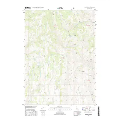
2017 Map of Mahogany Butte
USGS Topo · Published 2017About this map
Sawtooth National Forest dominates this high-altitude landscape in southern Idaho, where a complex network of springs and creek forks feeds the regional watershed. The terrain is defined by prominent peaks including Willow Creek Peak and Swanty Peak, alongside the namesake Mahogany Butte. Water sources are densely clustered across the slopes, with unique labels such as Thoroughbred Pond Spring, Right Hand Fork Spring, and Elk Basin Spring providing critical water in this arid environment. This 2017 survey details the complex topography of the Sawtooth range, documenting essential mountain crossings like Deerhorn Pass and Trout Creek Pass. The map reveals a backcountry landscape where named landmarks like Dads Hump, Joes Mtn, and Johnnys Canyon suggest a history of local usage and surveying. Significant drainages such as Thoroughbred Cr and Badger Cr carve through the high-elevation sections, illustrating the drainage patterns that define this part of Cassia County.
Find a feature on this map
107 named features on this map. Tap any name to fly to it.
Don’t see what you’re looking for? This feature index may not catch every label — zoom into the map to look around manually.
Map Details
Editions of this 2017 Mahogany Butte Map
This is the sole edition of this map. No revisions or reprints were ever made.
Other maps of this area

1955 · Twin Falls
USGS Topo · 1:250,000

1955 · Wells
USGS Topo · 1:250,000

1958 · Wells
USGS Topo · 1:250,000

1958 · Twin Falls
USGS Topo · 1:250,000

1961 · Wells
USGS Topo · 1:250,000

1961 · Gollaher Mountain
USGS Topo · 1:62,500

1961 · Goose Creek
USGS Topo · 1:62,500

1977 · Timber Butte
USGS Topo · 1:24,000

1977 · Mahogany Butte
USGS Topo · 1:24,000
1977 · Ibex Peak
USGS Topo · 1:24,000