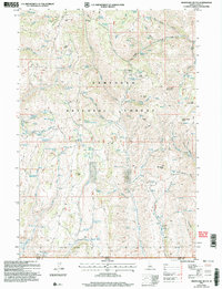
2001 Map of Mahogany Butte
USGS Topo · Published 2006About this map
Sawtooth National Forest dominates this high-altitude landscape along the southern border of Idaho, where the terrain is defined by complex drainage systems and a series of prominent peaks and passes. The map documents an area where the Cassia Co Elko Co line meets the Idaho Nevada state boundary, a region characterized by remote water sources and rugged topography. Significant landmarks such as Mahogany Butte, Monument Peak, and Trout Creek Mountain serve as key navigational points for those traversing the backcountry. The naming of features like Dads Hump, South Tit, and Pine Tit reflects local vernacular, while numerous springs—including Whitey Davis Spring and the historically significant WPA Spring—indicate the critical role of water management in these high-desert uplands. Multiple 4WD trails and mountain passes like Deerhorn Pass and Trout Creek Pass trace the historic movement through this borderland.
Find a feature on this map
65 named features on this map. Tap any name to fly to it.
Don’t see what you’re looking for? This feature index may not catch every label — zoom into the map to look around manually.
Map Details
Editions of this 2001 Mahogany Butte Map
This is the sole edition of this map. No revisions or reprints were ever made.
Other maps of this area

1955 · Twin Falls
USGS Topo · 1:250,000

1955 · Wells
USGS Topo · 1:250,000

1958 · Wells
USGS Topo · 1:250,000

1958 · Twin Falls
USGS Topo · 1:250,000

1961 · Wells
USGS Topo · 1:250,000

1961 · Gollaher Mountain
USGS Topo · 1:62,500

1961 · Goose Creek
USGS Topo · 1:62,500

1977 · Timber Butte
USGS Topo · 1:24,000

1977 · Mahogany Butte
USGS Topo · 1:24,000
1977 · Ibex Peak
USGS Topo · 1:24,000