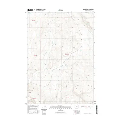
2015 Map of Mahogany Butte
USGS Topo · Published 2015About this map
Mahogany Butte rises as a prominent landmark in this arid portion of Washakie County, where a network of drainages defines the high desert landscape. The Nowood River meanders across the territory, joined by numerous seasonal watercourses including Redbank Cr, Box Elder Cr, and the three forks of Little Canyon Creek. This 2015 survey reflects a sparsely populated area primarily dedicated to open-range activities, as evidenced by several State Land Acc zones providing public entry points. Transportation in this corner of Wyoming is limited to a few arterial routes like CR-r82 and the winding Cherry Creek Rd. A notable human-made feature in the northwest corner is the Need Water Reservoir, a vital water management point for this dry environment. The map captures the specialized geography of the region, from the natural drainage of S V Draw to the winding course of Garden Cr.
Find a feature on this map
24 named features on this map. Tap any name to fly to it.
Don’t see what you’re looking for? This feature index may not catch every label — zoom into the map to look around manually.
Map Details
Editions of this 2015 Mahogany Butte Map
This is the sole edition of this map. No revisions or reprints were ever made.
Other maps of this area

1955 · Arminto
USGS Topo · 1:250,000

1958 · Arminto
USGS Topo · 1:250,000

1962 · Arminto
USGS Topo · 1:250,000

1966 · Big Trails
USGS Topo · 1:24,000
1966 · Tallon Spring
USGS Topo · 1:24,000

1966 · Indian Creek
USGS Topo · 1:24,000

1967 · Mahogany Butte
USGS Topo · 1:24,000
1967 · Cornell Gulch
USGS Topo · 1:24,000

1967 · Horse Butte
USGS Topo · 1:24,000
1967 · Lightning Ridge
USGS Topo · 1:24,000