
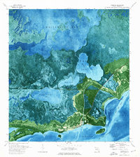
1972 Map of Mahogany Hammock
USGS Topo · Published 1975About this map
Mahogany Hammock stands as a distinct island of dense vegetation within the expansive wetlands of Everglades National Park. This 1972 orthophotomap provides a clear view of the hydrological and ecological patterns of the southern Florida landscape, where water levels were monitored at Gaging Station BM 2 and controlled via a local Pumping Station. The map illustrates the varied aquatic environments of the region, from the open waters of Pearl Bay to the secluded Paurotis Pond and Ninernile Pond. Human passage through this environment is marked by an Airboat Trail cutting through the sawgrass, while the boundary between Monroe and Dade counties bisects the western reaches. This survey captures a moment in the managed wilderness, documenting the essential landmarks used by rangers and researchers alike.
Find a feature on this map
9 named features on this map. Tap any name to fly to it.
Don’t see what you’re looking for? This feature index may not catch every label — zoom into the map to look around manually.
Map Details
Editions of this 1972 Mahogany Hammock Map
This is the sole edition of this map. No revisions or reprints were ever made.
Other maps of this area

1956 · Miami
USGS Topo · 1:250,000

1958 · Miami
USGS Topo · 1:250,000

1972 · Whitewater Bay East
USGS Topo · 1:24,000

1972 · Taylor Slough
USGS Topo · 1:24,000

1972 · Madeira Bay
USGS Topo · 1:24,000

1972 · West Lake
USGS Topo · 1:24,000

1972 · Long Pine Key
USGS Topo · 1:24,000

1972 · Tarpon Bay
USGS Topo · 1:24,000

1972 · Pa Hay Okee Lookout Tower
USGS Topo · 1:24,000
1973 · Flamingo
USGS Topo · 1:24,000