
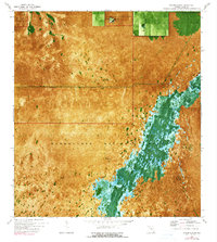
1972 Map of Taylor Slough
USGS Topo · Published 1975About this map
Everglades National Park dominates this 1970s orthophotomap, where the watery expanse of Taylor Slough creates a distinct pattern of sawgrass and tree islands. This unique hybrid map combines aerial photography with traditional topographic contours, revealing the subtle elevation changes that dictate the flow of water through this South Florida landscape. The Ingraham Highway cuts a straight line across the north, providing the primary human access point into the park's interior. A small Military Res is situated near the northern border, while a Gaging Sta and benchmark markers like BM 3 and BM 4 indicate the ongoing hydrologic monitoring essential for managing the swamp. The settlement of Areca appears as a small point of interest along the highway before it meets the headwaters of the slough.
Find a feature on this map
8 named features on this map. Tap any name to fly to it.
Don’t see what you’re looking for? This feature index may not catch every label — zoom into the map to look around manually.
Map Details
Editions of this 1972 Taylor Slough Map
2 editions found
Other maps of this area

1956 · Royal Palm Ranger Station
USGS Topo · 1:24,000

1956 · Royal Palm Ranger Station SE
USGS Topo · 1:24,000

1956 · Miami
USGS Topo · 1:250,000

1958 · Miami
USGS Topo · 1:250,000

1967 · Royal Palm Ranger Station SE
USGS Topo · 1:24,000

1972 · Mahogany Hammock
USGS Topo · 1:24,000

1972 · Madeira Bay
USGS Topo · 1:24,000

1972 · West Lake
USGS Topo · 1:24,000

1972 · Long Pine Key
USGS Topo · 1:24,000
1972 · Joe Bay
USGS Topo · 1:24,000