
1967 Map of Royal Palm Ranger Station SE
USGS Topo · Published 1967About this map
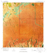
Everglades National Park dominates this experimental orthophotomap, showing the delicate water-and-land patterns of the southern Florida wilderness in the late 1960s. The topographic detail is overlaid on a photomosaic, providing a clear view of the Taylor Slough drainage system and the hammock island at Paradise Key. Human infrastructure is sparse, concentrated primarily on the eastern edge of the quadrangle where Canal 111 and Canal 111 E cut through the marsh. A few primitive trails and markers like Dawal 2 and a Gate provide the only orientation points within the expansive wet prairie. This specific edition is notable for its use of an early photomosaic technique, which better represents the complex textures of fresh water marsh, mangrove, and slough areas that traditional line drawings often struggle to categorize.
Find a feature on this map
9 named features on this map. Tap any name to fly to it.
Don’t see what you’re looking for? This feature index may not catch every label — zoom into the map to look around manually.
Map Details
Editions of this 1967 Royal Palm Ranger Station SE Map
2 editions found
Other maps of this area

1947 · Blackwater Sound
USGS Topo · 1:24,000

1949 · Blackwater Sound
USGS Topo · 1:24,000

1950 · Homestead
USGS Topo · 1:24,000

1950 · Glades
USGS Topo · 1:24,000

1956 · Homestead
USGS Topo · 1:24,000

1956 · Royal Palm Ranger Station
USGS Topo · 1:24,000

1956 · Glades
USGS Topo · 1:24,000

1956 · Royal Palm Ranger Station SE
USGS Topo · 1:24,000

1956 · Miami
USGS Topo · 1:250,000

1958 · Miami
USGS Topo · 1:250,000