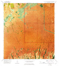
1967 Map of Royal Palm Ranger Station SE
USGS Topo · Published 1977About this map
Everglades National Park dominates this south Florida landscape, where the transition from sawgrass prairie to mangrove-lined drainage systems is captured in vivid detail. This 1967 orthophotomap emphasizes the hydrologic importance of Taylor Slough, a critical freshwater artery that feeds into the southern reaches of the park. The map reveals the intricate natural patterns of the wet season flow alongside the stark, man-made intervention of Canal 111, which cuts through the northeastern portion of the sheet near Dawal 2.
Find a feature on this map
7 named features on this map. Tap any name to fly to it.
Don’t see what you’re looking for? This feature index may not catch every label — zoom into the map to look around manually.
Map Details
Editions of this 1967 Royal Palm Ranger Station SE Map
2 editions found

Other maps of this area

1947 · Blackwater Sound
USGS Topo · 1:24,000

1949 · Blackwater Sound
USGS Topo · 1:24,000

1950 · Homestead
USGS Topo · 1:24,000

1950 · Glades
USGS Topo · 1:24,000

1956 · Homestead
USGS Topo · 1:24,000

1956 · Royal Palm Ranger Station
USGS Topo · 1:24,000

1956 · Glades
USGS Topo · 1:24,000

1956 · Royal Palm Ranger Station SE
USGS Topo · 1:24,000

1956 · Miami
USGS Topo · 1:250,000

1958 · Miami
USGS Topo · 1:250,000