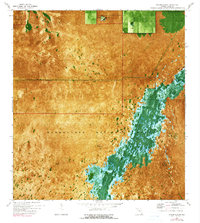
1972 Map of Taylor Slough
USGS Topo · Published 1990About this map
Taylor Slough dominates this orthophotomap, cutting a lush green swath through the marshy expanse of Everglades National Park. This 1972 survey, based on aerial photography from the previous year, provides a rare visual of the hydrological patterns of south Dade County during a period of critical environmental monitoring. The presence of a Gaging Sta along the slough indicates the ongoing efforts to measure water flow through this sensitive ecosystem. The Ingraham Highway provides the primary transit route through the terrain, bisecting the open sawgrass plains. Near the northern boundary, a Military Res stands as a distinct human footprint within the otherwise protected wilderness. The map's combination of photographic imagery and topographic contours allows for precise study of subtle elevation changes that dictate the movement of water across this subtropical landscape.
Find a feature on this map
7 named features on this map. Tap any name to fly to it.
Don’t see what you’re looking for? This feature index may not catch every label — zoom into the map to look around manually.
Map Details
Editions of this 1972 Taylor Slough Map
2 editions found
Other maps of this area

1956 · Royal Palm Ranger Station
USGS Topo · 1:24,000

1956 · Royal Palm Ranger Station SE
USGS Topo · 1:24,000

1956 · Miami
USGS Topo · 1:250,000

1958 · Miami
USGS Topo · 1:250,000

1967 · Royal Palm Ranger Station SE
USGS Topo · 1:24,000

1972 · Mahogany Hammock
USGS Topo · 1:24,000

1972 · Taylor Slough
USGS Topo · 1:24,000

1972 · Madeira Bay
USGS Topo · 1:24,000

1972 · West Lake
USGS Topo · 1:24,000

1972 · Long Pine Key
USGS Topo · 1:24,000