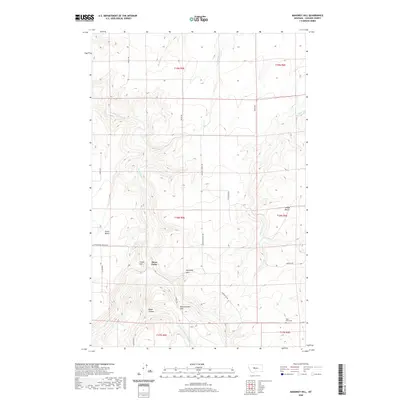
2020 Map of Mahoney Hill
USGS Topo · Published 2020About this map
Three Forks sits at the heart of this Cascade County landscape, where the dissected terrain is defined by a series of prominent benches and creek drainages. The naming of high ground such as Dutch Bench and Swede Bench reflects the area's homesteading history and ethnic settlement patterns. A complex network of coulees and ridges converges near Mahoney Hill and Blankenbaker Hill, while drainage systems like Sand Coulee Cr and Box Elder Cr carve through the topography. This rural landscape is anchored by local landmarks including the Tiger Butte Cem and the naming of roads such as Century School Rd, which points to the foundational role of early education in these ranching communities. The map provides a detailed view of the land partitions and natural features that have shaped life on this portion of the Montana plains.
Find a feature on this map
30 named features on this map. Tap any name to fly to it.
Don’t see what you’re looking for? This feature index may not catch every label — zoom into the map to look around manually.
Map Details
Editions of this 2020 Mahoney Hill Map
This is the sole edition of this map. No revisions or reprints were ever made.
Other maps of this area

1886 · Great Falls
USGS Topo · 1:250,000

1890 · Fort Benton
USGS Topo · 1:250,000

1892 · Fort Benton
USGS Topo · 1:250,000

1897 · Fort Benton
USGS Topo · 1:250,000

1954 · Great Falls
USGS Topo · 1:250,000

1955 · Stockett
USGS Topo · 1:62,500

1956 · Belt
USGS Topo · 1:62,500

1957 · Great Falls
USGS Topo · 1:250,000
1965 · Southeast Great Falls
USGS Topo · 1:24,000
1965 · Fife
USGS Topo · 1:24,000