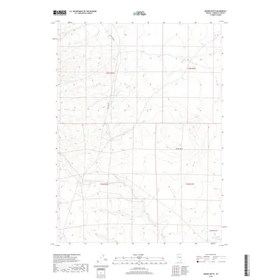
2018 Map of Maiden Butte
USGS Topo · Published 2018About this map
Maiden Butte rises above the arid stretches of Humboldt County, serving as a primary landmark in a landscape defined by seasonal water sources and expansive plateaus. This 2018 survey documents a region of the Owyhee Desert where the Little Owyhee River and smaller drainages like Calico Cr and Raven Cr carve through the high desert terrain. The presence of Maiden Springs and Twin Valley Springs indicates the vital, localized water points that have historically supported transit and ranching through this part of Nevada. While largely unpopulated, the area is accessible via the Quinn River Rd, reflecting the persistent reliance on established backcountry routes to navigate the large township blocks of the Great Basin.
Find a feature on this map
12 named features on this map. Tap any name to fly to it.
Don’t see what you’re looking for? This feature index may not catch every label — zoom into the map to look around manually.
Map Details
Editions of this 2018 Maiden Butte Map
This is the sole edition of this map. No revisions or reprints were ever made.
Other maps of this area

1882 · Paradise
USGS Topo · 1:250,000

1893 · Paradise
USGS Topo · 1:250,000

1955 · McDermitt
USGS Topo · 1:250,000

1959 · McDermitt
USGS Topo · 1:250,000

1980 · Calico Butte
USGS Topo · 1:24,000

1980 · Capitol Peak
USGS Topo · 1:24,000

1980 · Mahogany Spring
USGS Topo · 1:24,000
1980 · Button Lake
USGS Topo · 1:24,000

1980 · Greeley Flat
USGS Topo · 1:24,000
1980 · Maiden Butte
USGS Topo · 1:24,000