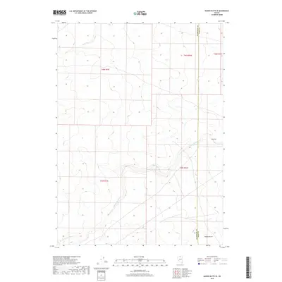
2018 Map of Maiden Butte SE
USGS Topo · Published 2018About this map
The Little Owyhee River snakes across this high desert landscape, cutting through the northwestern corner of the Owyhee Desert in Elko County. This 2018 survey documents a remote portion of the Great Basin, where the river's drainage patterns and the seasonal flow of Raven Cr define the topography. The map illustrates the surveyor's grid across the high-altitude terrain, notably along the north-south boundary separating Humboldt and Elko counties. Notable landmarks like Dobe Doc sit amidst a network of primitive roads and 4WD tracks, indicating the area's continued use for ranching or land management in an otherwise arid expanse. The lack of permanent structures emphasizes the isolated nature of this section of northern Nevada, preserved here in precise topographic detail.
Find a feature on this map
10 named features on this map. Tap any name to fly to it.
Don’t see what you’re looking for? This feature index may not catch every label — zoom into the map to look around manually.
Map Details
Editions of this 2018 Maiden Butte SE Map
This is the sole edition of this map. No revisions or reprints were ever made.
Other maps of this area

1882 · Paradise
USGS Topo · 1:250,000

1893 · Paradise
USGS Topo · 1:250,000

1955 · McDermitt
USGS Topo · 1:250,000

1959 · McDermitt
USGS Topo · 1:250,000

1973 · Star Valley Ridge SW
USGS Topo · 1:24,000

1973 · Button Lake Well
USGS Topo · 1:24,000
1973 · Star Valley Ridge West
USGS Topo · 1:24,000

1980 · Calico Butte
USGS Topo · 1:24,000
1980 · Button Lake
USGS Topo · 1:24,000

1980 · Greeley Flat
USGS Topo · 1:24,000