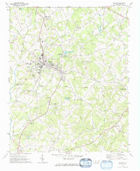
1970 Map of Maiden
USGS Topo · Published 1972About this map
Maiden anchors this Catawba County landscape, showing a structured town grid bisected by the Southern railroad. The surrounding Piedmont countryside is a mix of small industry and rural community life, featuring the Providence Mill and several community institutions like the State Prison Camp near Duan. The landscape is notably dense with country churches, ranging from Mays Chapel in the north to Bethel Ch and Moores Chapel further south, reflecting the deep-seated social geography of the area.
Find a feature on this map
59 named features on this map. Tap any name to fly to it.
Don’t see what you’re looking for? This feature index may not catch every label — zoom into the map to look around manually.
Map Details
Editions of this 1970 Maiden Map
2 editions found
Other maps of this area

1895 · Hickory
USGS Topo · 1:125,000

1909 · Lincolnton
USGS Topo · 1:62,500

1911 · Lincolnton
USGS Topo · 1:62,500

1914 · Gastonia
USGS Topo · 1:48,000

1916 · Gastonia
USGS Topo · 1:62,500

1953 · Charlotte
USGS Topo · 1:250,000

1954 · Charlotte
USGS Topo · 1:250,000

1960 · Charlotte
USGS Topo · 1:250,000

1962 · Charlotte
USGS Topo · 1:250,000
1970 · Lincolnton East
USGS Topo · 1:24,000