1970 Map of Maiden
USGS Topo · Published 1973About this map
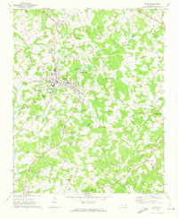
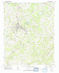
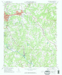
Maiden serves as the central hub of this Piedmont landscape, straddling the Catawba Co Lincoln Co line during the early 1970s. The town's layout is defined by the Southern rail line and a concentration of civic landmarks including the High Sch and several neighborhood houses of worship like East Maiden Ch. Just to the north, the presence of the State Prison Camp and the small settlement of Duan contrast with the more industrial character of the Filtration Plant and Providence Mill along Maiden Creek. The surrounding countryside is dotted with family-named churches and small water bodies, such as Gladdens Lakes and Horseshoe Lake, reflecting a region of dispersed rural communities and small-scale agriculture. Genealogists will find a wealth of local landmarks from Mays Chapel in the north to McKendree Ch and the settlement of Pumpkin Center in the south.
Find a feature on this map
50 named features on this map. Tap any name to fly to it.
Don’t see what you’re looking for? This feature index may not catch every label — zoom into the map to look around manually.
Map Details
Editions of this 1970 Maiden Map
2 editions found
Other maps of this area

1895 · Hickory
USGS Topo · 1:125,000

1909 · Lincolnton
USGS Topo · 1:62,500

1911 · Lincolnton
USGS Topo · 1:62,500

1914 · Gastonia
USGS Topo · 1:48,000

1916 · Gastonia
USGS Topo · 1:62,500

1953 · Charlotte
USGS Topo · 1:250,000

1954 · Charlotte
USGS Topo · 1:250,000

1960 · Charlotte
USGS Topo · 1:250,000

1962 · Charlotte
USGS Topo · 1:250,000
1970 · Lincolnton East
USGS Topo · 1:24,000