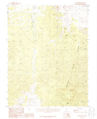
1985 Map of Mail Summit
USGS Topo · Published 1986About this map
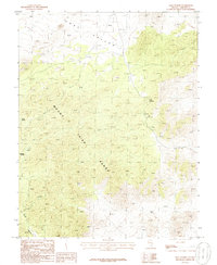
The Mount Irish Range dominates this mid-1980s landscape, illustrating a high-desert environment defined by steep relief and scarce water sources. This portion of Lincoln County is characterized by the broad expanse of Coal Valley to the north, giving way to the complex topography surrounding Mail Summit. Evidence of historical exploration and resource extraction is visible through the presence of Mine Shafts located near the head of Silver Canyon. These features, along with isolated water points like Henry Spring and Springer Spring, suggest a history of prospecting and ranching in a territory where movement was largely dictated by the natural corridors of the range. The map provides a precise look at the unimproved roads and trails that served as the primary infrastructure for this high-elevation basin-and-range country.
Find a feature on this map
7 named features on this map. Tap any name to fly to it.
Don’t see what you’re looking for? This feature index may not catch every label — zoom into the map to look around manually.
Map Details
Editions of this 1985 Mail Summit Map
This is the sole edition of this map. No revisions or reprints were ever made.
Other maps of this area

1954 · Caliente
USGS Topo · 1:250,000

1959 · Caliente
USGS Topo · 1:250,000
1970 · Seaman Wash
USGS Topo · 1:24,000
1970 · Fossil Peak
USGS Topo · 1:24,000
1970 · Hiko
USGS Topo · 1:24,000
1985 · Mount Irish
USGS Topo · 1:24,000

1985 · Crescent Spring
USGS Topo · 1:24,000
1985 · Mount Irish SE
USGS Topo · 1:24,000
1985 · Murphy Gap
USGS Topo · 1:24,000
1985 · Murphy Gap SE
USGS Topo · 1:24,000