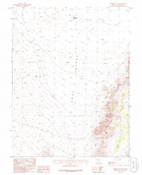
1985 Map of Murphy Gap SE
USGS Topo · Published 1986About this map
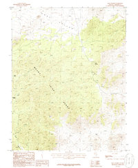
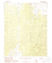
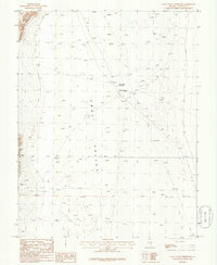
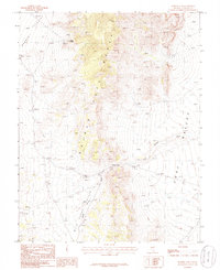
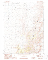
Coal Valley defines the core of this landscape in Lincoln County, where the desert floor is shaped by alluvial processes and shifting sand deposits. The 1980s terrain is characterized by broad drainage networks, notably Cold Springs Wash which carries seasonal runoff from the surrounding uplands toward the valley center. Water management in this arid environment is anchored by the Murphy Gap Reservoir in the northern reach, a critical landmark for livestock and local land use. While the region is primarily open range, network traces of 4wd tracks reveal the paths used by ranchers and mineral prospectors navigating this part of Nevada. This provisional survey provides a precise look at the topographical elevations and drainage patterns before modern digital mapping, preserving the specific hydrological and recreational landmarks of the mid-1980s.
Find a feature on this map
5 named features on this map. Tap any name to fly to it.
Don’t see what you’re looking for? This feature index may not catch every label — zoom into the map to look around manually.
Map Details
Editions of this 1985 Murphy Gap SE Map
This is the sole edition of this map. No revisions or reprints were ever made.
Other maps of this area

1954 · Caliente
USGS Topo · 1:250,000

1959 · Caliente
USGS Topo · 1:250,000
1970 · Oreana Spring
USGS Topo · 1:24,000
1970 · Seaman Wash
USGS Topo · 1:24,000
1970 · Fossil Peak
USGS Topo · 1:24,000
1985 · Mail Summit
USGS Topo · 1:24,000
1985 · Mount Irish
USGS Topo · 1:24,000
1985 · Coal Valley Reservoir
USGS Topo · 1:24,000
1985 · Murphy Gap
USGS Topo · 1:24,000
1985 · Murphy Gap NW
USGS Topo · 1:24,000