
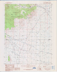
1985 Map of Murphy Gap NW
USGS Topo · Published 1986About this map
Garden Valley dominates the western portion of this 1980s landscape, a vast interior basin where the open terrain meets the rising contours of the Golden Gate Range to the east. This provisional survey captures the remote character of Lincoln County, highlighting the critical water sources required for life in the high desert, such as Put Back Spring located in the northern reaches of the quadrangle. The map is bisected by the Base Line, a fundamental surveying reference that coordinates the township and range system between Township 1 and 2 North. Landmarks like Rock Hill provide distinct topographic relief in an area primarily defined by drainage patterns and unimproved roads, offering a clear view of the Nevada backcountry before modern digital mapping replaced these manuscript-style drawings.
Find a feature on this map
7 named features on this map. Tap any name to fly to it.
Don’t see what you’re looking for? This feature index may not catch every label — zoom into the map to look around manually.
Map Details
Editions of this 1985 Murphy Gap NW Map
This is the sole edition of this map. No revisions or reprints were ever made.
Other maps of this area

1942 · Penoyer Valley
USGS Topo · 1:125,000

1954 · Caliente
USGS Topo · 1:250,000

1956 · Lund
USGS Topo · 1:250,000

1959 · Caliente
USGS Topo · 1:250,000

1960 · Lund
USGS Topo · 1:250,000

1985 · Worthington Peak
USGS Topo · 1:24,000

1985 · Water Gap East
USGS Topo · 1:24,000

1985 · Coal Valley Reservoir
USGS Topo · 1:24,000

1985 · Murphy Gap
USGS Topo · 1:24,000
1985 · Wadsworth Ranch
USGS Topo · 1:24,000