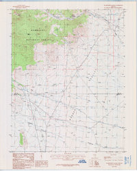
1985 Map of Wadsworth Ranch
USGS Topo · Published 1986About this map
Wadsworth Ranch and a neighboring Corral anchor the human presence in this high-desert landscape during the mid-1980s. Situated along the boundary between Nye and Lincoln counties, the area is defined by the broad expanse of Garden Valley and the steep, complex terrain of the Humboldt National Forest. The map captures a transition from the alluvial valley floor to the rugged uplands of Cherry Creek Canyon. Economic activity is evidenced by numerous Mine Shafts, prospects, and an adit concentrated near the canyons, reflecting a legacy of mineral exploration in this part of Nevada. Water remains the critical resource, with drainage systems like Cherry Creek, Pine Creek, and Cottonwood Creek cutting through the arid terrain toward the valley, while a Pack Trail suggests historical routes through the forest hills.
Find a feature on this map
18 named features on this map. Tap any name to fly to it.
Don’t see what you’re looking for? This feature index may not catch every label — zoom into the map to look around manually.
Map Details
Editions of this 1985 Wadsworth Ranch Map
This is the sole edition of this map. No revisions or reprints were ever made.
Other maps of this area

1942 · Penoyer Valley
USGS Topo · 1:125,000

1954 · Caliente
USGS Topo · 1:250,000

1956 · Lund
USGS Topo · 1:250,000

1959 · Caliente
USGS Topo · 1:250,000

1960 · Lund
USGS Topo · 1:250,000

1985 · Adaven
USGS Topo · 1:24,000

1985 · Worthington Peak
USGS Topo · 1:24,000

1985 · McCutchen Spring
USGS Topo · 1:24,000
1985 · Badger Gulch
USGS Topo · 1:24,000

1985 · Murphy Gap NW
USGS Topo · 1:24,000