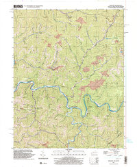
2001 Map of Majestic
USGS Topo · Published 2003About this map
Tug Fork and Knox Creek define the deep valleys and political boundaries of this coal-country landscape where Kentucky, West Virginia, and Virginia meet. At the start of the 21st century, the region's industrial character remains prominent through the Norfolk And Western railroad corridor and active extraction sites like Thacker Mines and several Strip Mines. Smaller settlements such as Majestic, Vulcan, and Stopover are connected by winding roads that follow the floor of steep hollows. Local heritage is preserved in landmarks like the Beech Creek Sch and Steele Cem, while the rugged geography is marked by numerous family-named branches and forks, including Meador Fork and Malachi Branch. This survey illustrates the intricate relationship between the region's natural drainage patterns and the infrastructure built to support its mining economy.
Find a feature on this map
63 named features on this map. Tap any name to fly to it.
Don’t see what you’re looking for? This feature index may not catch every label — zoom into the map to look around manually.
Map Details
Editions of this 2001 Majestic Map
This is the sole edition of this map. No revisions or reprints were ever made.
Other maps of this area

1886 · Grundy
USGS Topo · 1:125,000

1887 · Warfield
USGS Topo · 1:125,000

1890 · Grundy
USGS Topo · 1:125,000

1891 · Tazewell
USGS Topo · 1:125,000

1891 · Oceana
USGS Topo · 1:125,000

1891 · Warfield
USGS Topo · 1:125,000

1892 · Grundy
USGS Topo · 1:125,000

1893 · Oceana
USGS Topo · 1:125,000

1895 · Tazewell
USGS Topo · 1:125,000

1897 · Tazewell
USGS Topo · 1:125,000