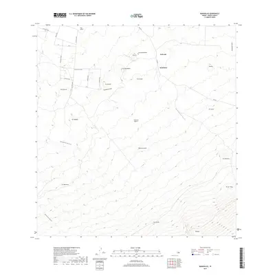
2017 Map of Makahalau
USGS Topo · Published 2017About this map
Makahalau serves as a focal point for this interior portion of the Island of Hawai'i, where the high-elevation landscape is defined by volcanic cones and deep drainages. Numerous volcanic vents, including Puu Kikoni, Pu'u'ula'ula, and Pu'ukaliali, dot the terrain, reflecting the geological processes that shaped the Hamakua and Kohala regions. The area is intersected by a network of local roads and forest routes such as Mana Rd and Makahalau Alanui, which provide access to these higher reaches. Deep natural incisions like Kuupahaa Gulch and Kemole Gulch channel runoff across the slopes. The map also captures the land divisions and peaks like Pūnohu and Pu'uhuluhulu, offering a look at the inland topography before it reaches the southern heights of Kemole.
Find a feature on this map
36 named features on this map. Tap any name to fly to it.
Don’t see what you’re looking for? This feature index may not catch every label — zoom into the map to look around manually.
Map Details
Editions of this 2017 Makahalau Map
This is the sole edition of this map. No revisions or reprints were ever made.
Other maps of this area

1915 · Hamakua
USGS Topo · 1:62,500

1916 · Waipio
USGS Topo · 1:62,500

1954 · Hawaii North
USGS Topo · 1:250,000

1956 · Kamuela
USGS Topo · 1:24,000

1956 · Keamuku
USGS Topo · 1:24,000

1956 · Nohonaohae
USGS Topo · 1:24,000

1956 · Makahalau
USGS Topo · 1:24,000
1956 · Ahumoa
USGS Topo · 1:24,000

1956 · Mauna Kea
USGS Topo · 1:24,000

1956 · Umikoa
USGS Topo · 1:24,000