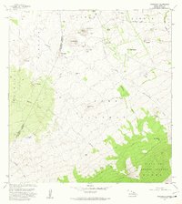
1981 Map of Makahalau
USGS Topo · Published 1981About this map
Kaohe Forest Reserve dominates the high-elevation slopes of the Big Island, where the South Kohala District and Hamakua District meet. The 1981 landscape is characterized by a series of cinder cones, or pu’u, such as Puu Makahalau and Puu Kiiaina, which dot the rising terrain. Ranching and land management are evident through named outposts like Makahalau and Paliaalii, along with numerous corrals and water tanks scattered across the slopes. The area is deeply incised by volcanic drainages, including the lengthy Kuupahaa Gulch and Kemole Gulch. At the northern edge, near the settlement of Mana, a small Cem and the lands of Waikoloa provide evidence of early high-country habitation and land use patterns before the terrain ascends into the more heavily forested reaches of the volcanic peaks.
Find a feature on this map
31 named features on this map. Tap any name to fly to it.
Don’t see what you’re looking for? This feature index may not catch every label — zoom into the map to look around manually.
Map Details
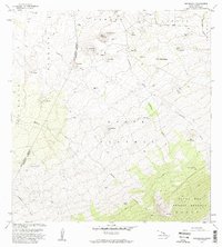
Editions of this 1981 Makahalau Map
2 editions found
Other maps of this area

1915 · Hamakua
USGS Topo · 1:62,500

1916 · Waipio
USGS Topo · 1:62,500

1954 · Hawaii North
USGS Topo · 1:250,000

1956 · Kamuela
USGS Topo · 1:24,000

1956 · Keamuku
USGS Topo · 1:24,000

1956 · Nohonaohae
USGS Topo · 1:24,000

1956 · Makahalau
USGS Topo · 1:24,000
1956 · Ahumoa
USGS Topo · 1:24,000

1956 · Mauna Kea
USGS Topo · 1:24,000

1956 · Umikoa
USGS Topo · 1:24,000