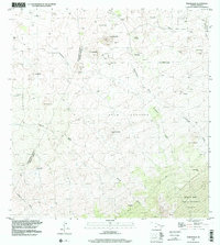
1993 Map of Makahalau
USGS Topo · Published 2001About this map
Mana and the settlement at Makahalau anchor this high-elevation landscape on the slopes of Mauna Kea, where the transition between the South Kohala and Hamakua Districts is marked by a network of ranching infrastructure. Numerous corrals and extensive rock walls crisscross the terrain, tracing the limits of traditional land divisions like Kamoku, Nienie, and Pa'Auhau. The map reveals a rugged geography defined by deep drainage channels such as Kuupahaa Gulch and Kemole Gulch, which cut through volcanic features like Pu'uhuluhulu and Pu'umakahalau. The southern portion of the sheet rises into the Mauna Kea Forest Reserve, showing a sparsely developed area where 4WD tracks provide the primary access to remote water tanks and family-named landmarks like Paliho'oukapapa. A lone Cemetery near Mana offers a point of interest for genealogists tracking early ranching families in the region.
Find a feature on this map
42 named features on this map. Tap any name to fly to it.
Don’t see what you’re looking for? This feature index may not catch every label — zoom into the map to look around manually.
Map Details
Editions of this 1993 Makahalau Map
This is the sole edition of this map. No revisions or reprints were ever made.
Other maps of this area

1915 · Hamakua
USGS Topo · 1:62,500

1916 · Waipio
USGS Topo · 1:62,500

1954 · Hawaii North
USGS Topo · 1:250,000

1956 · Kamuela
USGS Topo · 1:24,000

1956 · Keamuku
USGS Topo · 1:24,000

1956 · Nohonaohae
USGS Topo · 1:24,000

1956 · Makahalau
USGS Topo · 1:24,000
1956 · Ahumoa
USGS Topo · 1:24,000

1956 · Mauna Kea
USGS Topo · 1:24,000

1956 · Umikoa
USGS Topo · 1:24,000