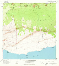
1963 Map of Makaopuhi Crater
USGS Topo · Published 1973About this map
Volcanic activity and sharp coastal escarpments define this section of the Hawaii Volcanoes National Park during the early 1960s. The landscape is a recent record of geological change, featuring specific paths of the 1962 Flow and the Lava Flow of 1923 across the Chain of Craters Road. The topography is dominated by massive pit craters such as Makaopuhi Crater, Pauahi Crater, and Alae Crater, alongside the prominent heights of Kane Nui o Hamo.
Find a feature on this map
45 named features on this map. Tap any name to fly to it.
Don’t see what you’re looking for? This feature index may not catch every label — zoom into the map to look around manually.
Map Details
Editions of this 1963 Makaopuhi Crater Map
2 editions found
Other maps of this area

1921 · Kilauea
USGS Topo · 1:62,500

1922 · Puna
USGS Topo · 1:62,500

1923 · Pahala
USGS Topo · 1:62,500

1924 · Kilauea
USGS Topo · 1:62,500

1924 · Puna
USGS Topo · 1:62,500

1954 · Hawaii South
USGS Topo · 1:250,000

1959 · Hawaii South
USGS Topo · 1:250,000

1961 · Hawaii South
USGS Topo · 1:250,000

1962 · Hawaii South
USGS Topo · 1:250,000
1963 · Volcano
USGS Topo · 1:24,000