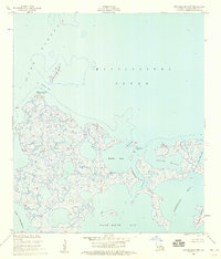
1955 Map of Malheureux Point
USGS Topo · Published 1959About this map
Malheureux Point and its surrounding wetlands represent a dynamic intersection of salt water and marsh in St. Bernard Parish during the mid-1950s. This survey, compiled from 1952 aerial photography and 1955 field checks, illustrates a coastal landscape defined by intricate waterways like Bayou La Fee and the Lakes of Bayou Marron. The map documents the shifting barrier elements of the outer marsh, including Le Petit Pass Island and Raccoon Island, which separate the interior bays from the open waters of Lake Borgne and the Mississippi Sound. Navigational markers such as the Ninemile Bayou Light at Blind Pass hint at the maritime activity required to traverse these shallow coastal reaches. The absence of roads or overland trails throughout the entire quadrangle emphasizes a wilderness defined entirely by its hydrology, where access was limited to those navigating the complex channels of South Bayou and False Mouth Bay.
Find a feature on this map
19 named features on this map. Tap any name to fly to it.
Don’t see what you’re looking for? This feature index may not catch every label — zoom into the map to look around manually.
Map Details
Editions of this 1955 Malheureux Point Map
2 editions found
Other maps of this area

1893 · Rigolets
USGS Topo · 1:62,500

1893 · Shell Beach
USGS Topo · 1:62,500

1893 · Toulme
USGS Topo · 1:62,500

1895 · Bodreau
USGS Topo · 1:62,500

1935 · English Lookout
USGS Topo · 1:31,680

1935 · Grand Island Pass
USGS Topo · 1:31,680

1936 · Rigolets
USGS Topo · 1:62,500

1939 · Shell Beach
USGS Topo · 1:62,500

1941 · Shell Beach
USGS Topo · 1:62,500

1946 · Oak Mound Bayou
USGS Topo · 1:31,680