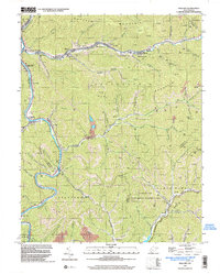
1996 Map of Mallory
USGS Topo · Published 2003About this map
Huff Creek and the Guyandotte River define the industrial and residential geography of Logan County in the late 20th century. This area is characterized by a dense concentration of gas wells and coal infrastructure, with several Mines Air Shafts and a Strip Mine located across the ridges of Triadelphia Mountain and Huff Mountain. The settlement pattern follows the narrow valley floors, connecting communities like Huff Junction, Mallory, and Mineral City along the CSX railroad corridor.
Find a feature on this map
76 named features on this map. Tap any name to fly to it.
Don’t see what you’re looking for? This feature index may not catch every label — zoom into the map to look around manually.
Map Details
Editions of this 1996 Mallory Map
This is the sole edition of this map. No revisions or reprints were ever made.
Other maps of this area

1891 · Oceana
USGS Topo · 1:125,000

1893 · Oceana
USGS Topo · 1:125,000

1898 · Oceana
USGS Topo · 1:125,000

1909 · Gilbert
USGS Topo · 1:48,000

1910 · Pineville
USGS Topo · 1:48,000

1910 · Bald Knob
USGS Topo · 1:48,000

1912 · Bald Knob
USGS Topo · 1:62,500

1912 · Gilbert
USGS Topo · 1:62,500

1912 · Pineville
USGS Topo · 1:62,500

1913 · Logan
USGS Topo · 1:62,500