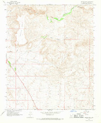
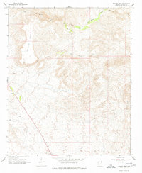
1967 Map of Malpais Mesa
USGS Topo · Published 1969About this map
Malpais Mesa dominates the landscape of this Yavapai County quadrangle as it appeared in the late 1960s. The terrain is defined by a series of drainage systems, most notably the South Fork Santa Maria River and the winding course of Black Canyon Wash. These seasonal watercourses are vital features in this arid environment, often punctuated by isolated water sources such as a Spring or Well that supported cattle or prospectors in the area. Evidence of human passage is sparse, indicated primarily by a Jeep Trail that navigates the complex topography. In the northeast, Waterman Creek feeds into the river system, illustrating the natural watershed patterns of the high desert before significant modern development altered the region's character.
Find a feature on this map
7 named features on this map. Tap any name to fly to it.
Don’t see what you’re looking for? This feature index may not catch every label — zoom into the map to look around manually.
Map Details
Editions of this 1967 Malpais Mesa Map
2 editions found
Other maps of this area

1887 · Prescott
USGS Topo · 1:250,000

1892 · Prescott
USGS Topo · 1:250,000

1903 · Congress
USGS Topo · 1:125,000

1904 · Congress
USGS Topo · 1:125,000

1923 · Signal
USGS Topo · 1:250,000

1942 · Signal
USGS Topo · 1:250,000

1950 · Prescott
USGS Topo · 1:250,000

1954 · Prescott
USGS Topo · 1:250,000

1958 · Prescott
USGS Topo · 1:250,000

1959 · Prescott
USGS Topo · 1:250,000