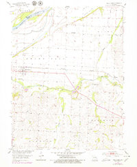
1953 Map of Malta Bend
USGS Topo · Published 1979About this map
Malta Bend anchors this mid-century portrait of Saline County, where the agricultural landscape meets the sweeping curves of the Missouri River. The area is defined by its water-management and transport infrastructure, from the Eugene Levee protecting the northern lowlands to the Missouri Pacific railroad line that passes through the heart of the settlement. The map reveals a community organized around rural social centers, including Lincoln School and several country churches.
Find a feature on this map
24 named features on this map. Tap any name to fly to it.
Don’t see what you’re looking for? This feature index may not catch every label — zoom into the map to look around manually.
Map Details
Editions of this 1953 Malta Bend Map
2 editions found
Other maps of this area

1890 · Marshall
USGS Topo · 1:125,000

1892 · Marshall
USGS Topo · 1:125,000

1901 · Marshall
USGS Topo · 1:125,000

1940 · Marshall
USGS Topo · 1:62,500

1944 · Marshall
USGS Topo · 1:62,500

1951 · Miami
USGS Topo · 1:24,000

1951 · Miami Station
USGS Topo · 1:24,000

1951 · Carrollton East
USGS Topo · 1:24,000

1953 · Moberly
USGS Topo · 1:250,000
1953 · Blackburn
USGS Topo · 1:24,000