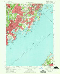
1967 Map of Mamaroneck
USGS Topo · Published 1969About this map
Long Island Sound dominates the southern half of this coastal survey, where the jagged shorelines of Westchester County meet the waters of Mamaroneck Harbor and Milton Harbor. The mid-century development of Harrison, Mamaroneck, and Rye is clearly visible, showing a landscape defined by expansive recreational grounds like the Westchester County Club and Apawamis Golf Club. Transportation corridors including the New England Thruway and the New York New Haven and Hartford railroad cut through the densely settled residential areas, linking these coastal communities to the broader metropolitan region.
Find a feature on this map
112 named features on this map. Tap any name to fly to it.
Don’t see what you’re looking for? This feature index may not catch every label — zoom into the map to look around manually.
Map Details
Editions of this 1967 Mamaroneck Map
2 editions found
Other maps of this area

1891 · Harlem
USGS Topo · 1:62,500

1892 · Stamford
USGS Topo · 1:62,500

1892 · Tarrytown
USGS Topo · 1:62,500

1893 · Stamford
USGS Topo · 1:62,500

1893 · Tarrytown
USGS Topo · 1:62,500

1897 · Harlem
USGS Topo · 1:62,500

1897 · Oyster Bay
USGS Topo · 1:62,500

1898 · Harlem
USGS Topo · 1:62,500

1898 · Oyster Bay
USGS Topo · 1:62,500

1899 · Stamford
USGS Topo · 1:62,500