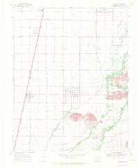
1967 Map of Manassa
USGS Topo · Published 1971About this map
Agricultural life in the San Luis Valley is defined by an intricate network of irrigation ditches and canals that radiate across the landscape of Conejos County. The settlement of Manassa serves as a central hub, flanked by the Denver and Rio Grande Western Railroad which runs parallel to U.S. 285. This 1967 field-checked survey highlights the community's local heritage through landmarks like Jack Dempsey Park and the Rodeo Ground, while preserving the locations of Old Manassa Cem, New Manassa Cem, and Soward Cem. The topography is dominated by the San Luis Hills and the meandering paths of the Conejos River and Rio San Antonio. The sheer volume of named water features, such as the Manassa Ditch and Bountiful Lateral, illustrates the critical importance of water management to the residents of nearby Romeo, Bountiful, and Los Cerritos.
Find a feature on this map
51 named features on this map. Tap any name to fly to it.
Don’t see what you’re looking for? This feature index may not catch every label — zoom into the map to look around manually.
Map Details
Editions of this 1967 Manassa Map
3 editions found
Other maps of this area

1922 · Conejos
USGS Topo · 1:125,000

1945 · Durango
USGS Topo · 1:250,000

1953 · Durango
USGS Topo · 1:250,000

1954 · Durango
USGS Topo · 1:250,000

1954 · Trinidad
USGS Topo · 1:250,000

1955 · Trinidad
USGS Topo · 1:250,000

1958 · Trinidad
USGS Topo · 1:250,000

1959 · Trinidad
USGS Topo · 1:250,000

1961 · Durango
USGS Topo · 1:250,000

1963 · Durango
USGS Topo · 1:250,000