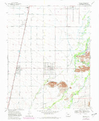
1967 Map of Manassa
USGS Topo · Published 1982About this map
The irrigated plains of the San Luis Valley are defined here by an intricate web of water management, where the Rio San Antonio and Conejos River feed a dense network of man-made channels including the Richfield Canal and Manassa Ditch. This 1967 survey captures the agricultural heart of the region, anchored by the town of Manassa, famed as the birthplace of boxing legend Jack Dempsey, commemorated here at Jack Dempsey Park. The settlement pattern follows the Denver and Rio Grande Western railroad, which links the communities of Romeo and Bountiful across the flat, high-altitude terrain. Notable for genealogists are the multiple burial sites, such as Old Manassa Cem and New Manassa Cem, reflecting the area’s deep-rooted Mormon pioneer heritage. To the east, the San Luis Hills rise above the wetlands of the Sego Springs State Wildlife Area, providing a sharp contrast to the gridded farmland.
Find a feature on this map
36 named features on this map. Tap any name to fly to it.
Don’t see what you’re looking for? This feature index may not catch every label — zoom into the map to look around manually.
Map Details
Editions of this 1967 Manassa Map
3 editions found
Other maps of this area

1922 · Conejos
USGS Topo · 1:125,000

1945 · Durango
USGS Topo · 1:250,000

1953 · Durango
USGS Topo · 1:250,000

1954 · Durango
USGS Topo · 1:250,000

1954 · Trinidad
USGS Topo · 1:250,000

1955 · Trinidad
USGS Topo · 1:250,000

1958 · Trinidad
USGS Topo · 1:250,000

1959 · Trinidad
USGS Topo · 1:250,000

1961 · Durango
USGS Topo · 1:250,000

1963 · Durango
USGS Topo · 1:250,000