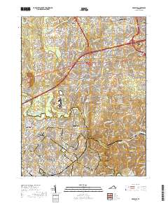
2019 Map of Manassas
USGS Topo · Published 2019About this map
Centreville and Manassas anchor this suburban landscape as it appeared in 2019, showing a dense network of residential developments and historical remnants. The map reveals the modern intersection of Interstate 66 and Us Highway 29, carving through the historical footprint of Northern Virginia. Amidst the suburban expansion of Fair Lakes and Greenbriar, numerous small family burial sites persist, such as the Stewart Family Cem and Turberville-Debell Family Cem, offering a tangible link to the region's 19th-century agrarian roots. To the west, the protected grounds of Manassas National Battlefield Park contrast with the modern growth of Yorkshire Park and Stonewall Acres. The Norfolk Southern line remains a central transit corridor, passing the Prince William County Judicial Center as it heads toward the historic town of Clifton, providing researchers with a clear view of how civil infrastructure and historical preservation coexist in the modern era.
Find a feature on this map
62 named features on this map. Tap any name to fly to it.
Don’t see what you’re looking for? This feature index may not catch every label — zoom into the map to look around manually.
Map Details
Editions of this 2019 Manassas Map
This is the sole edition of this map. No revisions or reprints were ever made.
Other maps of this area

1890 · Mt. Vernon
USGS Topo · 1:125,000

1891 · Mt. Vernon
USGS Topo · 1:125,000

1894 · Warrenton
USGS Topo · 1:125,000

1894 · Mt. Vernon
USGS Topo · 1:125,000

1897 · Mt. Vernon
USGS Topo · 1:125,000

1915 · Fairfax
USGS Topo · 1:62,500

1927 · Quantico
USGS Topo · 1:62,500

1933 · Middleburg
USGS Topo · 1:62,500

1940 · Quantico
USGS Topo · 1:62,500

1943 · Quantico
USGS Topo · 1:62,500