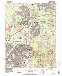
1990 Map of Manassas
USGS Topo · Published 1996About this map
Centreville and the burgeoning residential corridors of northern Virginia are documented here in the early 1990s, showcasing a landscape where suburban expansion meets significant American history. The area is defined by the sharp contrast between dense housing developments like London Towne or Cloverleaf Farm Estates and the preserved grounds of Manassas National Battlefield Park and Bull Run Regional Park. This map reveals the transformation of historical farmland into a modern commuter hub, while still following the natural drainage of Cub Run and Big Rocky Run.
Find a feature on this map
57 named features on this map. Tap any name to fly to it.
Don’t see what you’re looking for? This feature index may not catch every label — zoom into the map to look around manually.
Map Details
Editions of this 1990 Manassas Map
This is the sole edition of this map. No revisions or reprints were ever made.
Other maps of this area

1890 · Mt. Vernon
USGS Topo · 1:125,000

1891 · Mt. Vernon
USGS Topo · 1:125,000

1894 · Warrenton
USGS Topo · 1:125,000

1894 · Mt. Vernon
USGS Topo · 1:125,000

1897 · Mt. Vernon
USGS Topo · 1:125,000

1915 · Fairfax
USGS Topo · 1:62,500

1927 · Quantico
USGS Topo · 1:62,500

1933 · Middleburg
USGS Topo · 1:62,500

1940 · Quantico
USGS Topo · 1:62,500

1943 · Quantico
USGS Topo · 1:62,500