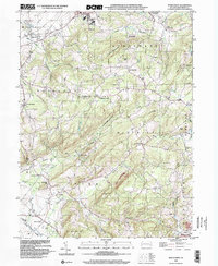
1999 Map of Manatawny
USGS Topo · Published 2002About this map
Topton Mountain serves as the topographic centerpiece of this Berks County landscape, where the waters of the Sacony Creek and Bieber Creek navigate a complex network of ridges and small gaps. The area is characterized by a high density of small, established settlements like Fredericksville, Lobachsville, and Topton, reflecting a long history of rural community life in Pennsylvania's Piedmont region. Genealogists will find significant value in the preservation of local landmarks, including the notable Mountain Marys Grave and several historic houses of worship such as Hill Church and St Pauls Ch. The presence of State Game Lands No 315 and a Covered Br near the village of Manatawny underscores the mix of public conservation and traditional infrastructure that persists in these townships.
Find a feature on this map
52 named features on this map. Tap any name to fly to it.
Don’t see what you’re looking for? This feature index may not catch every label — zoom into the map to look around manually.
Map Details
Editions of this 1999 Manatawny Map
This is the sole edition of this map. No revisions or reprints were ever made.
Other maps of this area

1894 · Reading
USGS Topo · 1:62,500

1902 · Boyertown
USGS Topo · 1:62,500

1902 · Slatington
USGS Topo · 1:62,500

1909 · Hamburg
USGS Topo · 1:62,500

1911 · Hamburg
USGS Topo · 1:62,500

1913 · Reading
USGS Topo · 1:62,500

1915 · Reading
USGS Topo · 1:62,500

1937 · Allentown West
USGS Topo · 1:48,000

1942 · Allentown West
USGS Topo · 1:62,500

1943 · Manatawny
USGS Topo · 1:31,680