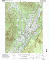
1997 Map of Manchester
USGS Topo · Published 2000About this map
Manchester and the surrounding Bennington County landscape appear here as a well-established hub of valley commerce and recreation at the close of the twentieth century. The Vermont Railway corridor serves as the spine for a string of settlements including East Dorset, Manchester Center, and Manchester Depot, illustrating a historical development pattern constrained by the steep rise of Equinox Mountain to the west and the Lye Brook Wilderness to the east.
Find a feature on this map
73 named features on this map. Tap any name to fly to it.
Don’t see what you’re looking for? This feature index may not catch every label — zoom into the map to look around manually.
Map Details
Editions of this 1997 Manchester Map
This is the sole edition of this map. No revisions or reprints were ever made.
Other maps of this area

1893 · Wallingford
USGS Topo · 1:62,500

1894 · Londonderry
USGS Topo · 1:62,500

1894 · Pawlet
USGS Topo · 1:62,500

1894 · Equinox
USGS Topo · 1:62,500

1896 · Equinox
USGS Topo · 1:62,500

1897 · Pawlet
USGS Topo · 1:62,500

1899 · Londonderry
USGS Topo · 1:62,500

1900 · Equinox
USGS Topo · 1:62,500

1903 · Mettawee
USGS Topo · 1:125,000

1950 · Glens Falls
USGS Topo · 1:250,000