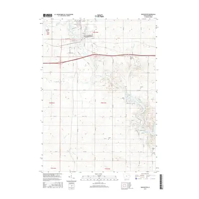
2015 Map of Manchester
USGS Topo · Published 2015About this map
Manchester serves as the focal point of this Delaware County landscape, situated where the Maquoketa River flows south toward the impounded waters of Hartwick Lake. The town's grid is well-defined by historic thoroughfares like W Main St and S Brewer St, supporting a community infrastructure that includes the Manchester Municipal Airport to the northwest. Outside the residential center, the terrain is shaped by a dense network of tributaries including Coffins Creek, Sand Cr, and Todds Cr. For those researching local history, the map provides precise locations for a notable concentration of burial grounds, ranging from the central Oakland Cem and Saint Marys Cem to more rural sites like Hamblin Cem and Milo Township Cem. This 2015 update documents the modern road system, including Co Hwy X15 and Co Hwy D5X, while preserving the locations of legacy family landmarks such as the Sands Farm Cem.
Find a feature on this map
43 named features on this map. Tap any name to fly to it.
Don’t see what you’re looking for? This feature index may not catch every label — zoom into the map to look around manually.
Map Details
Editions of this 2015 Manchester Map
This is the sole edition of this map. No revisions or reprints were ever made.
Other maps of this area

1900 · Anamosa
USGS Topo · 1:125,000

1901 · Oelwein
USGS Topo · 1:125,000

1902 · Elkader
USGS Topo · 1:125,000

1903 · Winthrop
USGS Topo · 1:125,000

1959 · Dubuque
USGS Topo · 1:250,000

1961 · Dubuque
USGS Topo · 1:250,000

1962 · Dubuque
USGS Topo · 1:250,000

1965 · Thorpe
USGS Topo · 1:24,000
1965 · Greeley
USGS Topo · 1:24,000

1965 · Dundee
USGS Topo · 1:24,000