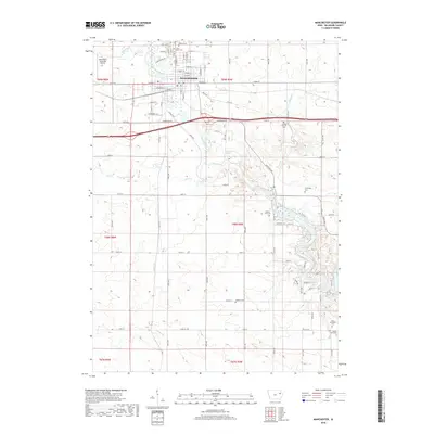
2018 Map of Manchester
USGS Topo · Published 2018About this map
The Maquoketa River winds through the heart of Manchester, serving as the primary geographical anchor for this section of Delaware County. The town layout is clearly defined by its historic street grid, including W Main St and E Main St, which transition into rural routes as they leave the municipal center. The surrounding landscape is a patchwork of agricultural sections, marked by an unusually high density of small family and township burial grounds. Genealogists will find significant value in the distribution of these sites, from Oakland Cem and Saint Marys Cem near the town center to more remote locations like Sands Farm Cem and Milo Township Cem to the south. Further north, the Manchester Municipal Airport and the confluence of Coffins Creek with the river show the evolution of local transportation and drainage patterns in this Iowa community.
Find a feature on this map
42 named features on this map. Tap any name to fly to it.
Don’t see what you’re looking for? This feature index may not catch every label — zoom into the map to look around manually.
Map Details
Editions of this 2018 Manchester Map
This is the sole edition of this map. No revisions or reprints were ever made.
Other maps of this area

1900 · Anamosa
USGS Topo · 1:125,000

1901 · Oelwein
USGS Topo · 1:125,000

1902 · Elkader
USGS Topo · 1:125,000

1903 · Winthrop
USGS Topo · 1:125,000

1959 · Dubuque
USGS Topo · 1:250,000

1961 · Dubuque
USGS Topo · 1:250,000

1962 · Dubuque
USGS Topo · 1:250,000

1965 · Thorpe
USGS Topo · 1:24,000
1965 · Greeley
USGS Topo · 1:24,000

1965 · Dundee
USGS Topo · 1:24,000