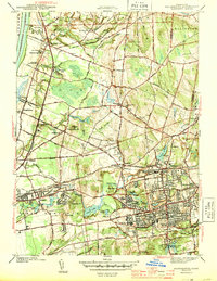
1944 Map of Manchester
USGS Topo · Published 1944About this map
Manchester and South Manchester appear as the primary industrial and residential hubs of this 1940s landscape, anchored by the New York New Haven and Hartford RR. The terrain is marked by a transition from the built-up streets of the Manchester center to the more dispersed agricultural settlements of Wapping and East Windsor Hill. Water plays a central role in the local economy and geography, with the Hockanum River feeding sites like Hilliard Pond and powering the mills that defined early regional development.
Find a feature on this map
67 named features on this map. Tap any name to fly to it.
Don’t see what you’re looking for? This feature index may not catch every label — zoom into the map to look around manually.
Map Details
Editions of this 1944 Manchester Map
3 editions found

Other maps of this area

1892 · Hartford
USGS Topo · 1:62,500

1892 · Tolland
USGS Topo · 1:62,500

1892 · Gilead
USGS Topo · 1:62,500

1893 · Middletown
USGS Topo · 1:62,500

1906 · Farmington
USGS Topo · 1:125,000

1921 · Tolland
USGS Topo · 1:62,500

1928 · Windsor Locks
USGS Topo · 1:24,000

1928 · Windsor
USGS Topo · 1:24,000

1928 · Glastonbury
USGS Topo · 1:24,000

1928 · Broad Brook
USGS Topo · 1:24,000