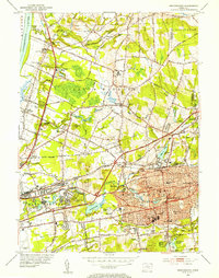
1952 Map of Manchester
USGS Topo · Published 1954About this map
Manchester and its surrounding villages show a dense network of suburban growth and traditional industry at the mid-century mark. The landscape is defined by the Hockanum River and its various millponds, such as Hilliards Pond and Union Pond, which historically powered the local textile and paper manufacturing sectors. In the north, the transition from the tobacco-growing flats of South Windsor and East Windsor is evident, with clusters of family-named sites like the Jonathan Edwards Cem and East Windsor Hill reflecting early colonial roots. The transportation backbone is provided by the New York New Haven and Hartford railroad lines and the Wilbur Cross Highway, which fueled the expansion of neighborhoods like Sunset Ridge and Burnham. Educational and religious centers, including Wapping High Sch and St Bridgets Cem, anchor these developing communities.
Find a feature on this map
122 named features on this map. Tap any name to fly to it.
Don’t see what you’re looking for? This feature index may not catch every label — zoom into the map to look around manually.
Map Details
Editions of this 1952 Manchester Map
3 editions found
Other maps of this area

1892 · Hartford
USGS Topo · 1:62,500

1892 · Tolland
USGS Topo · 1:62,500

1892 · Gilead
USGS Topo · 1:62,500

1893 · Middletown
USGS Topo · 1:62,500

1906 · Farmington
USGS Topo · 1:125,000

1921 · Tolland
USGS Topo · 1:62,500

1928 · Windsor Locks
USGS Topo · 1:24,000

1928 · Windsor
USGS Topo · 1:24,000

1928 · Glastonbury
USGS Topo · 1:24,000

1928 · Broad Brook
USGS Topo · 1:24,000