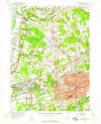
1952 Map of Manchester
USGS Topo · Published 1959About this map
Manchester and its surrounding villages show the dense mid-century development of the Connecticut River Valley just as post-war suburbanization began to bridge the gap between historic town centers. This 1952 revision captures the area’s transition from a landscape of scattered family-named settlements like Farnhams and Burnham to a more integrated industrial and residential hub. Educational and civic growth is evident in the numerous facilities such as Ellsworth High Sch, Nathan Hale Sch, and the Armory.
Find a feature on this map
80 named features on this map. Tap any name to fly to it.
Don’t see what you’re looking for? This feature index may not catch every label — zoom into the map to look around manually.
Map Details
Editions of this 1952 Manchester Map
3 editions found
Other maps of this area

1892 · Hartford
USGS Topo · 1:62,500

1892 · Tolland
USGS Topo · 1:62,500

1892 · Gilead
USGS Topo · 1:62,500

1893 · Middletown
USGS Topo · 1:62,500

1906 · Farmington
USGS Topo · 1:125,000

1921 · Tolland
USGS Topo · 1:62,500

1928 · Windsor Locks
USGS Topo · 1:24,000

1928 · Windsor
USGS Topo · 1:24,000

1928 · Glastonbury
USGS Topo · 1:24,000

1928 · Broad Brook
USGS Topo · 1:24,000