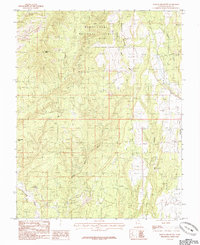
1985 Map of Mancos Jim Butte
USGS Topo · Published 1985About this map
The Manti-La Sal National Forest occupies the northern reaches of this San Juan County landscape, where the high desert terrain is defined by a complex network of seasonal drainages and geological markers. The prominent Mancos Jim Butte and Black Steer Knoll stand as significant navigational landmarks for those studying the topography of southeastern Utah during the mid-1980s. The drainage patterns on this sheet are particularly intricate, with Brushy Basin Wash and Dry Wash carving through the center, while Big Canyon and Cottonwood Wash dominate the southern and eastern margins. This 1985 survey, produced as a provisional map from 1970s field data, captures the era's land management boundaries and the natural watercourses like Johnson Creek and Westwater Creek that dictate the region's accessibility.
Find a feature on this map
9 named features on this map. Tap any name to fly to it.
Don’t see what you’re looking for? This feature index may not catch every label — zoom into the map to look around manually.
Map Details
Editions of this 1985 Mancos Jim Butte Map
This is the sole edition of this map. No revisions or reprints were ever made.
Other maps of this area

1886 · Abajo
USGS Topo · 1:250,000

1892 · Abajo
USGS Topo · 1:250,000

1893 · Abajo
USGS Topo · 1:250,000

1935 · Elk Ridge
USGS Topo · 1:96,000

1940 · Elk Ridge
USGS Topo · 1:125,000

1954 · Elk Ridge 4 NW
USGS Topo · 1:24,000

1954 · Elk Ridge 1 SW
USGS Topo · 1:24,000

1954 · Elk Ridge 1 SE
USGS Topo · 1:24,000
1954 · Mt Linnaeus
USGS Topo · 1:62,500

1956 · Cortez
USGS Topo · 1:250,000