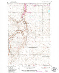
1950 Map of Manfred NW
USGS Topo · Published 1986About this map
The Sheyenne River winds through this Central North Dakota landscape, its course modified by the creation of the Harvey Dam State Wildlife Management Area. This 1950s-era topography shows a rural environment defined by the rectangular grid of section lines across Western, Forward, and Rusland townships. The map reflects a period when one-room schoolhouses and country churches served the agricultural community, with the presence of Whitby Sch No 3, School No 2, and St Peters Ch marking the social hubs of the prairie. In the northeast corner, Egg Lake and the Soo Line railroad provide geographical anchors, while the southern terrain is carved by the namesake Pony Gulch. Local industry is represented by a small Gravel Pit, typical of the region's reliance on local materials for road building.
Find a feature on this map
12 named features on this map. Tap any name to fly to it.
Don’t see what you’re looking for? This feature index may not catch every label — zoom into the map to look around manually.
Map Details
Editions of this 1950 Manfred NW Map
2 editions found
Other maps of this area

1940 · Aylmer
USGS Topo · 1:62,500

1941 · Selz
USGS Topo · 1:62,500

1945 · Manfred
USGS Topo · 1:62,500

1946 · Sheyenne Lake
USGS Topo · 1:48,000

1947 · Sheyenne Lake
USGS Topo · 1:62,500

1948 · Manfred
USGS Topo · 1:62,500

1949 · Manfred SW
USGS Topo · 1:24,000

1950 · Manfred SE
USGS Topo · 1:24,000

1950 · Wellsburg
USGS Topo · 1:24,000

1950 · Manfred NW
USGS Topo · 1:24,000