
1950 Map of Manfred NW
USGS Topo · Published 1950About this map
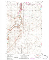
The Sheyenne River meanders through this section of Wells County, carving a valley between the Western and Forward townships. This 1950 survey reveals a rural landscape deeply organized around its local education system, with a high density of rural schoolhouses such as Pioneer Sch No 3, Whitby Sch No 3, and Eigenheim School No 2 serving the dispersed prairie homesteads. The terrain transitions into the distinct geographic regions of Pony Gulch and Rusland, where the land is marked by small prairie potholes and depressions.
Find a feature on this map
16 named features on this map. Tap any name to fly to it.
Don’t see what you’re looking for? This feature index may not catch every label — zoom into the map to look around manually.
Map Details
Editions of this 1950 Manfred NW Map
2 editions found
Other maps of this area

1940 · Aylmer
USGS Topo · 1:62,500

1941 · Selz
USGS Topo · 1:62,500

1945 · Manfred
USGS Topo · 1:62,500

1946 · Sheyenne Lake
USGS Topo · 1:48,000

1947 · Sheyenne Lake
USGS Topo · 1:62,500

1948 · Manfred
USGS Topo · 1:62,500

1949 · Manfred SW
USGS Topo · 1:24,000

1950 · Manfred SE
USGS Topo · 1:24,000

1950 · Wellsburg
USGS Topo · 1:24,000

1950 · Sheyenne Lake NE
USGS Topo · 1:24,000